Weather – It’s The Variability That’s Hard To Farm With
PART II - TEMPERATURE
Author: Guy Ash, Global Training Manager, Pessl Instruments
In Part I of our series, we discussed the critical role that localized weather data and precipitation play in effective farm management. We explored how site-specific rainfall measurements can significantly impact decision-making and crop success.
Now, in Part II, we shift our focus to another crucial weather variable—temperature. Temperature affects evapotranspiration, frost risk, crop growth and development, spraying operations (Delta T), and disease susceptibility. Understanding temperature variability and its impact on different aspects of farming is key to optimizing yields and minimizing losses. In this article, we’ll dive into how site-specific temperature data can enhance crop management and decision-making, leading to better efficiency and improved farm productivity.

TEMPERATURE: impacts evapotranspiration, frost potential, growth and development, spraying operation (Delta T), disease risk
How does Temperature Variation impact crop management? Temperature can be influenced by changes in elevation; this is clearly seen with cooler temperatures at increasing height. It also occurs in low lying areas that are prone to cooler temperatures during frost events (called frost hollows). The cover of vegetation also has a direct impact on temperature, where a cultivated soil will have much higher temperatures than a grass covered field during the day.
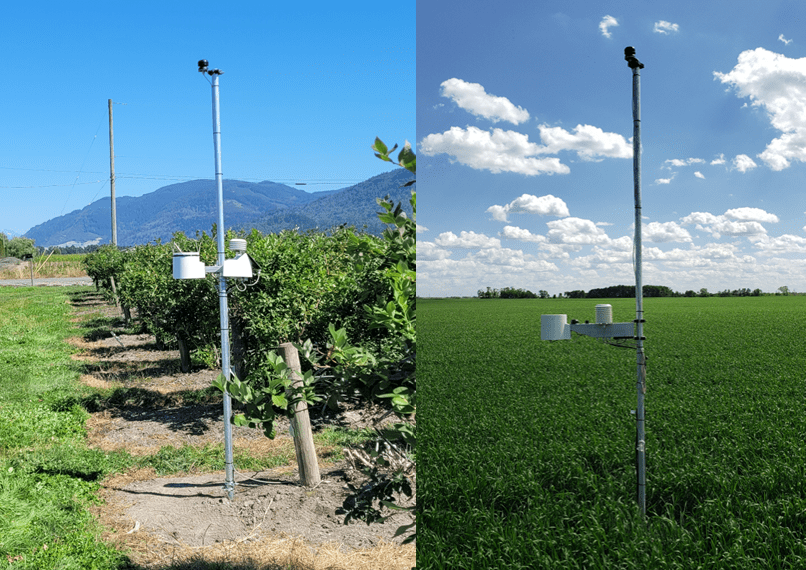
The installation height of the sensor can also have a significant impact on the temperature reading. Soil surface readings during a sunny day are substantially higher than temperatures measured at the standard 1.5-meter height. During a clear night with light winds, temperatures at the ground can be 5 to 6 °C cooler by morning, then air temperature measured at 1.5 meters, due to long wave radiation losses from the surface. This is called a temperature inversion and is a very important factor to account for in spraying since it can lead to spray drift concerns.

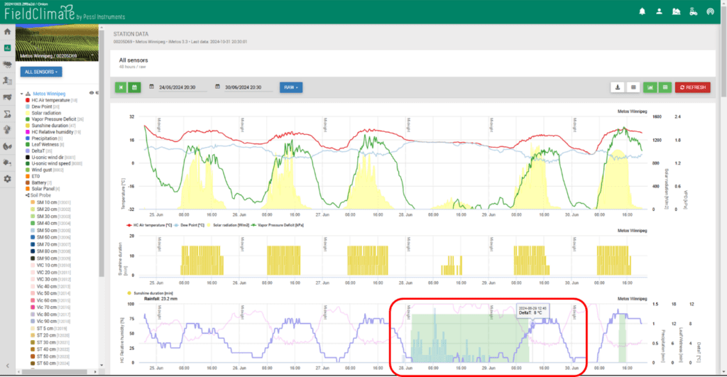
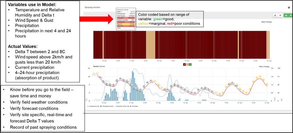
Along with temperature inversions, perhaps one of the most important meteorological factors to consider when spraying is Delta T. Delta T simply put, is about the survivability of droplets once it leaves the spray nozzle.
It is calculated based on a relationship between air temperature and relative humidity, where very warm and dry conditions can lead to evaporation of the droplet, while damp and cool conditions can lead to poor leaf deposition and absorption.
The typical range for good spray operations is between 2 to 8-10 (image below). Both the in-field and forecasted Delta T values are available with an in-field station, providing the highest level of accuracy and timing of spray operations.
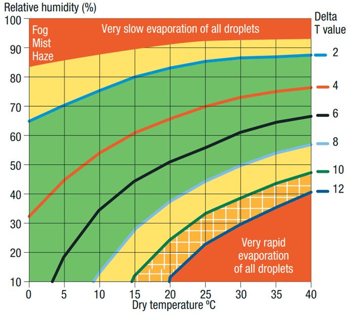
The typical range for good spray operations is between 2 to 8-10 (image below). Both the in-field and forecasted Delta T values are available with an in-field station, providing the highest level of accuracy and timing of spray operations.
COST OF SPRAYING INEFFICIENCIES
Pesticide efficacy varies depending on weather conditions from 20 to 100%. Pesticide inefficiency can reduce quality by up to 80% and yield by up to 30%.
For a soybean crop with a 60 bu/acre yield potential, but a high disease incidence of sclerotinia, and yield loss because of pesticide inefficiency of 8% on $9.50 bu soybeans translates into $45.6 (4.8 bu/acre * $9.5) lost income per acre.
FROST DAMAGE AND PROTECTION
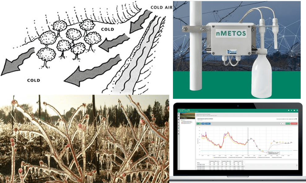
Where you have an orchard, vineyard, berry or vegetable field with variations in geographic elevation, it’s recommended to install a strategic placement of frost devices, so that low spots (frost hollows) are monitored and the appropriate protective measures are taken (irrigation, air mixing, etc.).
The actual conditions for wet-dry bulb temperature are then combined with a site-specific forecast of wet-dry bulb temperature, which provides the ideal prediction solution for frost management. You can imagine trying to use a weather station that is km’s or miles from your location to make the decision on frost management, your answer would be inaccurate.
DEW POINT TEMPERATURE
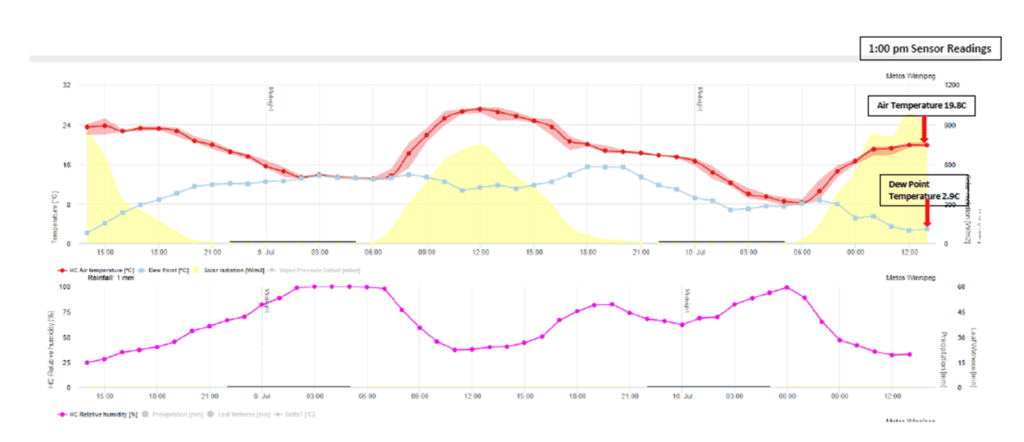
Dew point is the temperature at which water vapor held in the air will condense to form a liquid, or it is the temperature to which air cools when dew is formed. So, when the dew point temperature is equal to the air temperature, the relative humidity is 100%.
As air temperature continues to rise above the dew point temperature, the relative humidity values will be lower, while when the air temperature cools towards the dew point the relative humidity will increase. Dew point temperature can be used to predict when a radiative frost will take place. For example, if the skies are clear, winds are light, and the air temperature at 6 PM is 8 °C (46.4 °F), but the dew point is -2 °C (28.4 °F), then there is a potential for frost overnight or early the next morning.
Again, this is the potential to which the temperature can drop to under ideal conditions, but most likely not the actual low temperature because of mitigating circumstances.
High dew points can be used as a prediction of severe weather. The higher the dew point, the more moisture in the air for severe weather development. If dew points are below 13 °C (<55.4 °F) conditions are generally stable, if temperatures are between 13 °C to 18 °C (55.4 °F to 64.5 °F) semi moist and semi unstable, 18 °C to 23.5 °C (64.5 °F to 74.5 °F) moist and unstable and above 23.5 °C (>74.5 °F) very moist and very unstable. There are several other factors required for severe weather, but dew point temperature is an important factor.

IMPORTANCE OF SITE-SPECIFIC TEMPERATURE
Of course, site specific temperature is an important factor in crop and insect development and water-use of the crop. It is essential for determining the length of the growing season and the amount of useful heat accumulated, known as growing degree days (GDD).
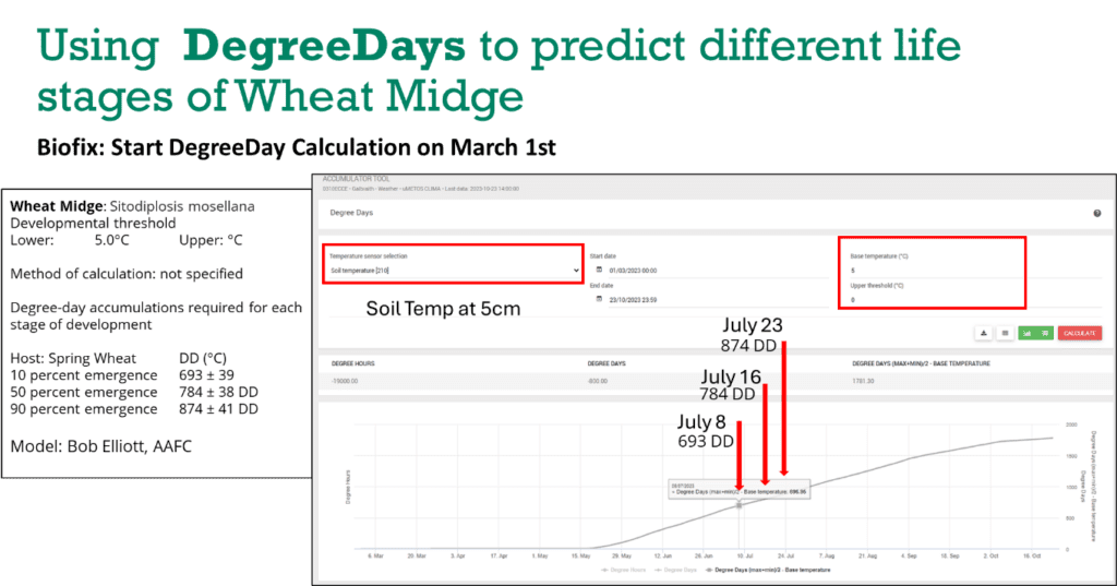
Growing degree-days for any base and upper temperature should be calculated at the field, so that accurate growth stages of crop development can be estimated for various field activities, e.g. spraying. Temperature or growing degree-days can also be used for estimating insect stages and development, if the correct sensor installation is used. In some cases, temperature measurement in the soil at 5 cm or 2 inches is used (soil temperature probe), while other insects can use a sensor installed at the traditional 1.5 meters.
The image below illustrates the predicted life stages of Wheat Midge using a growing degree-day (GDD) model based on soil temperature. The dates provided by the GDD model were the same as the field level traps.
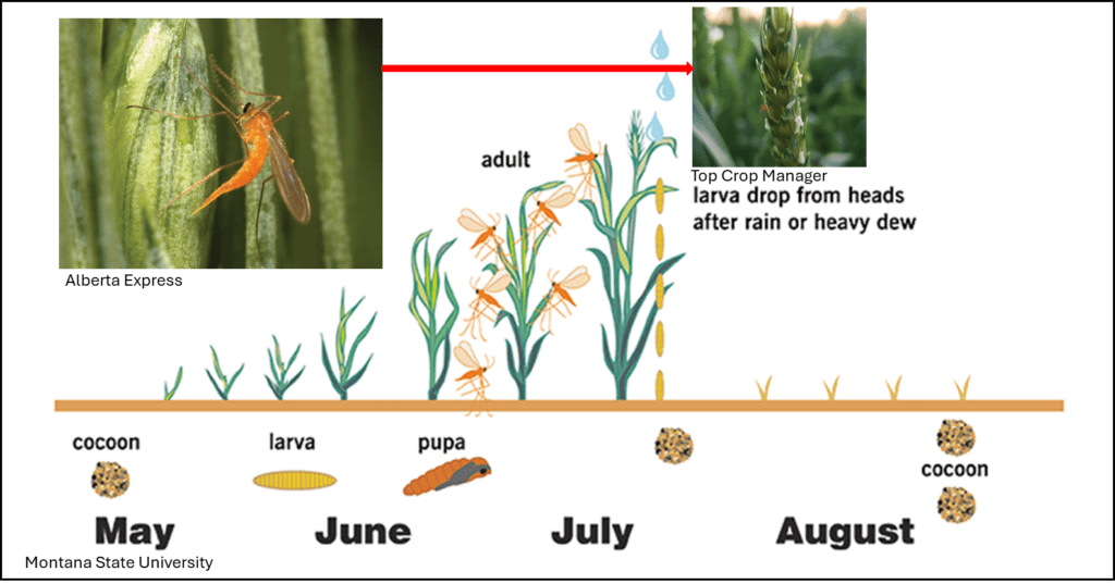
Cost of Wheat Midge Damage: Wheat midge can impact both yield and grade. At an infestation level of 1 midge for every 4 to 5 wheat heads, yields can be reduced by 15%. On a 60 bushel crop, this can result in 9 bu/acres lost or $54 per acre ($6 bu wheat). The economic loss from grade can also be significant if 1 midge is found per 8 to 10 heads of wheat. Depending on the level down grading (e.g., #1 to #2 or #1 to #3) this can range from $4 per ton for #1 to #2 and $10 per ton for #1 to #3 CWRS.
KEY TAKEAWAYS FROM PART II
Temperature variability is one of the most significant factors influencing agricultural success. From frost protection to effective spraying and insect control, having accurate, real-time, site-specific temperature data can mean the difference between optimal crop performance and substantial losses.
By integrating advanced weather stations, predictive models, and localized forecasting, growers can mitigate risks and improve their operational efficiency. In a world where climate unpredictability is increasing, leveraging data-driven farming practices is no longer an option—it’s a necessity.
Enjoyed this?
You might also like the PART III that’s coming out next week. Subscribe to be the first to read it.
